
August / 14 / 2026
By: Timothy Elikem Harvor and Alena Thiel
This article takes to heart the special issue’s call to decentering the conversation around multiple African AnthropoScenes. It proposes collaborative theorization of African environmental knowledge encounters in climate change and disaster adaptation. With the 2023 mid‐term review of the Sendai Framework, knowledge practices have been re‐confirmed as a priority area of Disaster Risk Reduction (DRR). While DRR datafication has largely been standardized in global infrastructure such as the DesInventar platform, a “multiverse” of knowledge practices (Di Fiore et al. 2023: 55) informs DRR interventions on the ground. Drawing on the notion of intersecting method assemblages (Ruppert and Scheel 2019, 2021), this article traces the knowledge encounters that shape how disaster is understood, predicted and addressed in grassroots settings in Ghana. Taking flood risk as a case, we theorize the production of forecasts and early warning signs at the intersection of quantitative, computational modelling (earth observation) and the generation of not (yet) formalized knowledges about environmental and disaster risks (community‐based environmental knowledges), including in more‐than‐human encounters with sentinel species.
Keywords: sentinel species, knowledge encounters, method assemblage, disaster risks.
In 2023, the United Nations set the global goal to protect “everyone on Earth from hazardous weather, water or climate events through life-saving early warning systems” by 2027 (Early Warning for All, 2024). Yet, while there is ample evidence that early warning systems save lives and assets, African countries in particular suffer unacceptably higher incidences of deaths attributed to disaster than any other world region (EW4A Dashboard, 2024). In part, this is due to Brunet et al.’s observation (2023) that climate change has exacerbated disasters often not only in frequency and magnitude, but also in complexity, as multiple threats to human security unfold in compound ways. As a result, unprecedented weather patterns and disaster scenarios render past observations less useful for predictive modelling purposes. This is at odds with the recent trend towards neoliberal approaches to disaster risk reduction and resilience, e.g. in strengthening disaster insurance, which – at its core – is a matter of the comprehensive datafication of disaster risks.
Our argument intervenes in this debate with a close-up investigation of Ghana’s efforts in inclusive production of knowledge about disaster risks, and the ordering of various forms of disaster knowledge in complex “method assemblages” (Ruppert et al., 2013). Our aim is to assess how DRR interventions play out in the “multiverse” of expert knowledge practices, and specifically, in relation to their variously ordered claims to validity (Di Fiore et al., 2023, p. 55). By doing so, we shift our gaze away from the problematic hubris of digital techno-fixes and the romanticization of community-based knowledge practices alike, to recenter our view onto the data practices that declare disaster knowledge at the heart of state knowledge production, here, in Ghana’s National Disaster Management Organization (NADMO).
In 2023, the mid-term review of the Sendai Framework for Disaster Risk Reduction (SFDRR) reconfirmed the significance of knowledge practices as a foremost priority area of disaster risk reduction (DRR). In particular, SFDRR Priority 1 “Understanding disaster risk” emphasizes the need for evidence-based policy and practice in “pre-disaster risk assessment, for prevention and mitigation and for the development and implementation of appropriate preparedness and effective response to disasters.” This includes, at national and local levels, “the collection, analysis, management and use of relevant data and practical information”, among other types of knowledge, real-time access to geographic information systems (GIS), “location-based disaster risk information, including risk maps” but also “the use of traditional, indigenous and local knowledge and practices” (SFDRR, 2015, p. 14-16, see also Mercer et al., 2010). However, focus on these goals eclipses the complex solutions required for data collection, cleaning, storage, analysis, and communication of highly diverse forms of data and knowledge. Our chosen lens of method assemblages allows us to address this silence, foregrounding the interaction between these knowledge types, and the ways in which they enhance each other or at times cancel each other out.
The article proceeds by detailing the collaboration of impact-based forecasting, geo-information systems, community-based knowledges, and the observation of sentinel species. To be sure, other forms of knowledge production and innovation play significant roles in DRR datafication. We take the October 2023 spilling of Ghana’s historically iconic Akosombo hydroelectric dam as a timely case to emphasize the co-construction of plural methods of prediction and early warning around flood risk. Data for this article stems from long-term professional practice of the lead-author in Ghana’s National Disaster Management Organization, as well as ethnographic data collected by the second author as part of the project [####].
In our view, the datafication of disasters rests on continuously shifting “method assemblages” that include “advocates and their claims, conceptions of populations, and investments in material practices [as well as concepts, and techniques] and digital devices for generating data and, in turn, enacting populations” at risk (Ruppert and Scheel, 2019, p. 234). Hoeyer et al. (2019, p. 460) expand on this idea, noting how knowledge assemblages represent “arrangements of practices, technologies, and theories that configure action in a sociotechnical space”. Crucially, then, Hoeyer et al. remind us that assemblages are mediated “at all levels” by science and technology, and thus require us to engage the “discursive as well as numerical logics” as well as the “material practices through which [assemblages] emerge and come to have effects” (ibid.), for example their effects to “diversify, expand and stratify responsibility in new ways” (ibid., p. 467, 469).
We take these interventions as inspiration to investigate how the authority to declare various forms of knowing about disasters is widely distributed across people, national and international organizations, but also material devices as well as more-than-human encounters with sentinel species. Orienting towards assemblage thinking, then allows us to conceptualize DRR data practices as “composed of partially connected elements, as well as correlated, coercive and conflicting forces” ordering them in ever shifting patterns (Olwig et al., 2019, p. 5, 8).
Observations for this article were collected in the aftermath of the September 2023 spillage of Ghana’s historically iconic Akosombo dam and hydroelectric power plant. Despite prior announcement, the controlled spillage on 15 September 2023 – which released 183.000 cubic feet of water per day – displaced over 35,000 people and destroyed numerous communities. Built in 1961-1965, at 1,020 MW capacity, Akosombo to date still generates a lion’s share of Ghanaian electricity supply and export (VRA, 2024). This makes it an infrastructure of significant economic but also political importance, especially in view of popular dissatisfaction around irregular electricity supply. However, climate change and increasingly unpredictable rain patterns render the management of water levels more and more difficult. In the following sections, we interrogate how different actors “know” about impending disaster such as flood risks.
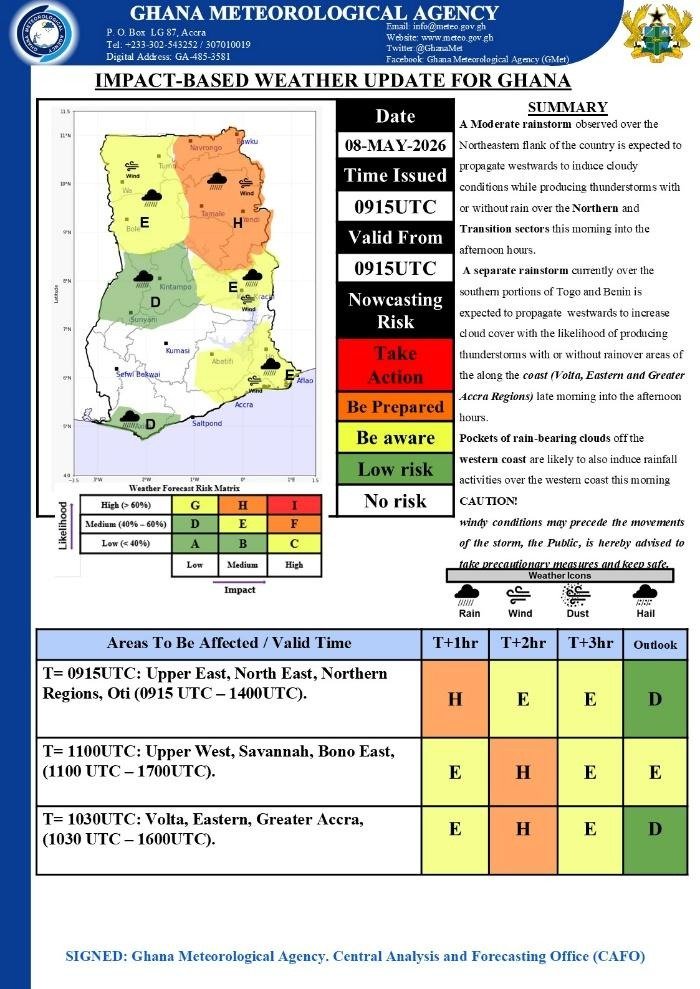
Figure 2: Impact-based weather update for Ghana with colour-coded weather warnings for the territory of Ghana
Source: NADMO Emergency Operation Center, received from the Ghana Meteorological Agency
Ghana Meteorological Service (GMet) represents the first line of defense in securing against risks of flood. For planning purposes, GMet provides disaster organizations with annual and seasonal forecasts. These seasonal trends are then updated by daily, impact-based forecasts, or when relevant, impact-based weather warnings. Impact-based forecasting entails detailed assessments of what weather will do to communities and infrastructure, accompanied by specific likelihood thresholds and detailed recommendations (“be prepared”, “take action”) for the affected localities. GMet here follows communication guidelines of the WMO, indicating both likelihood and severity of impact in a clear, color-coded risk matrix to enable better decision-making for populations at risk and to work more effectively with stakeholders, such as the emergency services.
In 2021, GMet further accelerated forecasting with support from GCRF African SWIFT and the University of Leeds. In this initiative to deliver nowcasting infrastructure and applications to Ghana, a satellite dish and NWC-SAF (Nowcasting Satellite Applications Facility) was installed at Kwame Nkrumah University of Science and Technology. Its aim was to deliver near-real-time early warning information to users including among others, Ghana Maritime Authority, Ministry of Agriculture, Ghana Fishermen’s Association, as well as Volta River Authority responsible for the maintenance and operation of Akosombo dam and power plant (GCRF, 2021). While this program has significantly advanced the development of nowcasting products (especially Rapidly Developing Thunderstorm, RDT), at the time of writing, GMet attests to currently receiving real-time observations from the World Meteorological Organization as continuous financing of the Ghanaian dish’s maintenance and repair could not be secured. This observations points clearly to an important socio-technical dimension of the method assemblage: the perpetual problem of funding data infrastructure and innovation, but also the training and staff required “to generate and issue public warnings based on a nowcast process” (GCRF, 2021) and to connect them to other relevant knowledges, especially in geoinformation. The next section will detail this work.
NADMO’s Centre for Geospatial and Big Data initiates disaster risk management by conducting remote sensing analysis of flood-prone areas using satellite imagery from the United States Geological Survey (USGS). The primary aim of this analysis is to identify flood and drought risks by comparing year-to-year remote sensing data of areas of interest designated as flood prone. Additionally, the center maintains a comprehensive database of vector data on crucial landscape features essential for disaster management, including the locations of NADMO offices, inventories of disaster response critical facilities, and infrastructure.
During a flood disaster, NADMO employs a multifaceted approach to monitor and analyze the impacts. This includes near real-time sentinel imagery analysis specifically on the UNSPIDER platform, which enables the organization to rapidly assess the extent and severity of the flood. Additionally, Unmanned Aerial Vehicles (UAVs) are utilized for aerial photography, through which high-resolution images of affected areas are used to assess the extent of impacts, particularly in inaccessible regions.
The sentinel imagery analysis process begins with the activation of a charter for flood incident mapping, which involves the appointment of a project manager and technical personnel to assist in the mapping effort. In the recent flood incident resulting from the Akosombo Dam spillage, the charter was activated, and a project manager residing in Brazil was appointed. Two technical personnel were selected from NADMO in Ghana and the National Emergency Management Agency (NEMA) in Nigeria. Together, this team produced various maps to analyze the impact of the flood, providing critical insights for disaster response and mitigation efforts.
During disasters, UAVs play a crucial role in assessing the impact of the disaster, particularly in inaccessible areas, communities and farms that are cut off from access roads. This technology is often used to identify stranded victims and plan rescue missions. The UAVs have been extensively utilized in the northern part of the country, particularly during the rainy season, which coincides with the spillage of the Bagre Dam, located in Burkina Faso, on the White Volta.
Another key datapoint used in impact assessment is Call Data, which is generated in collaboration with Vodafone Ghana (now Telecel) and the Ghana Statistical Service. This data is based on communication patterns between cell phones and cell towers, including text messages, calls, and internet data usage. This innovative approach, championed by Flowminder, an organization based in the UK and Switzerland, enables the NADMO to assess migration patterns of people around a disaster point and provides valuable insights into population movements and displacement patterns.
While technological and method innovation are of crucial importance to accelerate disaster interventions, they are complemented by a host of other knowledges. The following sections detail the participation of traditional and community-based knowledge in Ghana’s DRR efforts.
Certain species, following Lakoff (2016, p. 244), “function as a sentinel device—alerting us to the approach of an uncertain but catastrophic threat”. For Lakoff (ibid.), sentinel species thus are “part of a precautionary apparatus: an alert that tells us we must take action, even in the face of uncertainty, to avert disaster. ” The inherent difficulty, Lakoff details, is that “such signals of warning face challenges in spurring intervention. When the stakes of intervention are high—when precautionary measures are costly—the validity of the sentinel’s warning, or its relation to an imagined future, is often contested” (ibid.). We are here interested in the credibility of the sentinel, and the significant sociotechnical investments required to turn observation of sentinel species into method. This Lakoff cautioned, is contingent on moving beyond affective care about a certain species population to the realization of their symptomatic status of a “broader, unfolding tragedy” (ibid.: 243). Besides the moment of valuation and hence enactment as a certain good, this move entails significant efforts of standardization, measurement and the work of “comparity” (Schinkel, 2016) to transform environmental observations into evidence – as opposed to practices of divination (Beisel, Calkins & Rottenburg, 2018) – from which ensues a certain responsibilization.
Ghana is host to myriad sentinel species (UNDP, 2012) as the country’s territory spans multiple ecological zones and cultural as well as socio-lingual orientations towards the environment (Atobrah, 2018). As an illustration of this, Ghana’s northern savannah hosts sentinel species that are seen as predictors of droughts, such as the economically significant shea tree which is seen as morally involved in communities’ resilience by carrying bulk fruit prior to drought years hence economically “helping” people in times of hardship. Similarly, a variety of insect and bird species represent indicators of impending floods as they are observed to adjust their nesting and migratory patterns. Coastal regions in turn orient specifically towards water-borne risks, such as tidal waves, which fisherfolk attune to through observations of environmental indicators such as distinct wave patterns. Let us look closer at specific indicators and knowledges related to flood risks.
Many Ghanaian communities have developed their own traditional methods of weather forecasting that are deeply rooted in their local knowledge and observations. One such technique is the use of cloud observations to predict the onset of the rainy season. In many communities, particularly in southern regions, people closely monitor the appearance of dark clouds in the sky right after the dry season is coming to an end. The early appearance of these dark clouds is seen as a reliable indicator that the rainy season is about to begin. This traditional weather forecasting method is highly valuable for agricultural communities, as it allows them to time their planting and other farming activities accordingly. By observing the clouds and predicting the start of the rains, farmers usually take steps to ensure that their crops are sown at the optimal time to take advantage of the incoming rains. This traditional knowledge has been passed down through generations and continues to be an important part of disaster preparedness and risk management strategies in many rural and indigenous communities. The integration of these time-tested, community-based weather forecasting techniques with scientific data have greatly enhance the accuracy and effectiveness of disaster early warning systems at the community levels.
In some river communities, the migration patterns of certain ant species have become a reliable indicator of impending flooding. The Dorylus ants, which are known as swamp-loving ants, is one such species that is closely monitored. These ants are typically found in floodplains and are known to migrate away from these areas before a flood occurs. By observing the ants’ movements, community members and farmers anticipate the onset of flooding and take necessary precautions to protect their homes, farms and livelihoods. Another traditional sign of flooding is the cry of the Torlem bird at night and the appearance of specific fish species in rivers. The Torlem bird is known to make its nest in grass in marshy areas just a little above the water. In the event of floods, the nest gets drawn. For this reason, the bird is known to make a crying sound at night when it anticipates impending floods. In some communities, the presence of certain fish species is seen as a warning sign that water levels are about to rise and flooding is imminent. This knowledge is often tied to the local ecosystem and is based on observations of the fish’s behavior and migration patterns.
In addition to these signs, people living in community near flood zones of rivers closely monitor water levels marked on trees and grasses to plan evacuations and avoid disasters. This traditional method involves taking daily notice of water levels on trees and grasses as the water rises. This allows community members to track changes in the water level and anticipate potential flooding. Regularly checking these marks provides local data for community members to plan their daily activities accordingly and make informed decisions about when to evacuate or take other necessary precautions.
In river communities, homes and other structures are often designed and constructed with resilience in mind, particularly in the face of frequent flooding. One key aspect of this is the use of locally available and affordable materials such as clay, mangrove timber, and grasses. These materials are not only cheap but also durable, making them well-suited for building structures that need to withstand the forces of nature. Community members construct homes and other buildings that are better equipped to withstand the impacts of flooding and rainstorms.
Another key feature of resilient building techniques in these communities is the construction of the base of buildings. The base is typically built with multiple layers of hard mangrove timber and clay mud, which dry to become solid and provides a strong foundation that can resist the forces of floodwaters. This layered construction also helps to prevent water from seeping into the structures, reducing the risk of damage and ensuring that the building remains safe and habitable. Additionally, the base of the structure is often expanded to be twice or three times larger than the upper sections, which helps to prevent flooding from affecting and slowly ‘eating’ away the entire structure. This design feature allows the building to absorb the impact of floodwaters without compromising its integrity.
Furthermore, clay mounts are often hipped at the base of buildings to enhance their resilience. These mounts are designed to absorb and distribute the force of floodwaters, reducing the risk of damage to the structure. The incorporation of clay mounts into the construction of buildings safeguards people in many of these communities to further reduce the risk of flood-related damages. This ensures that homes and other structures remain safe and secure, playing a vital role in the disaster preparedness and risk management strategies of river communities.
In river communities, a common practice is to build homes on high ground between creeks and rivulets of major river channels. This is very common in areas around North and South Tongu Districts. This strategic location is chosen because flooding in these areas is generally more predictable and less severe compared to lower grounds closer to the creeks, rivulets and the main river channels. By building on higher ground, community members avoid the risks associated with flooding. The predictability of flooding in these areas allows residents to plan and prepare accordingly and reduce the likelihood of unexpected and catastrophic events. Additionally, the lower risk of flooding in these areas also means that the impact of flooding is less severe. Therefore, homes and structures are able to withstand the forces of nature more easily. One of the factors that contributed to the high impacts of flooding resulting from the Akosombo Dam spillage has been the decline in this building practice. The narrative had it that because of the construction of the Akosombo Dam, such level of flooding has not happened in 63 years. Thus, people forgot the impacts of the floods and built in low-lying areas.
This observation is mirrored in other areas across the country. During interviews in communities along the shores of the Keta Lagoon – affected for weeks by secondary effects of the Akosombo spillage – officials and disaster volunteers in both communities explained that from the community’s perspective, flood risk mapping is largely habitual and based on historical knowledge of past floods. In the case of Keta, historical experience complicated disaster management, delaying the necessary opening of the Keta Lagoon sandbar to release surplus water from the Akosombo spillage into the Gulf of Guinea. In view of these contradictions and complexities, how is community-based knowledge meaningfully integrated in disaster institutions’ records and decision making?
6. Incorporating Traditional Knowledge and Scientific Data
Incorporating traditional knowledge into scientific data is a crucial aspect of disaster management in many riverine communities. Community disaster volunteers and taskforces play a vital role in this process by combining traditional signs of flooding with scientific data to warn people of impending dangers. This approach helps to enhance disaster preparedness and response by combining local knowledge with scientific methods. The integration of signs of natural phenomena, such as the migration patterns of the Dorylus ant species, the cry of the Torlem bird at night, or the appearance of specific fish species, with scientific data, helps community members and local disaster management groups gain a more comprehensive understanding of the risks associated with flooding. This integrated approach enables them to make more informed decisions about evacuation, resource allocation, and other critical aspects of disaster management. The strengths of integrating traditional knowledge and scientific methods enable community disaster volunteers and taskforces to develop more effective and targeted disaster preparedness and response strategies, ultimately saving lives and reducing the impact of disasters on communities.
This represents a two way communication, as officials closely interact with local actors, such as chiefs and other authorities to distribute early warning information to communities at risk. In the experience of these experts, official warnings can be ignored when environmental signs indicate conflicting messages. “You know that the ground saturates before the water comes in, so if the ants keep their eggs in this sand, people tell you that ‘this year, the water will not reach us”. In view of this, it is critical to communicate inclusively.
NADMO’s reporting chain may provide a major benefit here, combining qualitative and quantitative data in the form of situational reports at the district level, with reporting following the standard indicators of the global DesInventar platform at regional and national levels. UNDRR DesInventar platform, a “tracking system for hazardous events and losses and damages”, records and displays aggregated data from national disaster organizations in the reporting countries, perpetuating thereby a data imaginary of the encompassing monitoring of disaster across the globe. This work of streamlining disaster knowledge into globally comparable indicators, interviews with managers in various regional head offices of NADMO indicate, is complex. For once, while the Excel sheets designed by NADMO’s national headquarters are locked and uniform to ensure “comparity”, training in completing the form in decentral sites is less streamlined. As was pointed out at various moments, Ghana’s recent designation of six new regions following the 2018 referendum meant that reporting infrastructure needed to be extended onto new offices and staff. During interviews, several voices indicated that not all regions take equal care to complete the reporting form in its entirety or misunderstand sections of the tool. Data quality assurance, hence, relies on experienced staff able to see through the cracks in the reports and to be able to reinvestigate disaster events based on written reports and photographic evidence accompanying the data sheets. Here, qualitative measures come to play a significant role.
We began this article with a discussion of the shifting nature of the method assemblage, which evades singular ordering principles. As assemblages are by their very nature fluid, determining the definitory power to declare how disasters ought to be measured and for which purpose emerges as a complex social question.
The material presented in this article only scratches the surface of the multiverse of data practices that make up disaster datafication in Ghana. To name a recent example, digital innovations such as the AgriEWS application promise to reorder reporting channels and dissemination of early warning directly through the mobile phones of farmers and other affected populations. Hydrological modeling, e.g. through Ghana’s Water Resource Commission significantly participates in understanding the multiple flood risks that affect the country. Importantly, this article has not attended to the labor of monitoring, quantifying and reporting disaster events and impacts at the local level, especially through the participation of disaster volunteer groups and district-based NADMO officers, who play crucial roles in assessing and reporting disaster risks and events.
Nonetheless, our argument around an ever shifting, emerging DRR method assemblage raises critical points about the valuation of different technologies and forms of knowing the environment. Here we return to Hoeyer et al. ‘s argument that although assemblages are “legitimized with reference to the need for numbers and ‘knowledge about what works” the assemblage also selects “the numbers it uses to justify” certain decisions, disregarding other types of evidence (2019, p. 469). For Hoeyer et al. then, “[t]here is not one single process of ‘datafication’ (…) but different systems generating different objects of concern through different ways of counting and by holding different actors accountable. These assemblages continue to work through both words and numbers” (2019, p. 470).
We have shown here that disaster knowledge is situated in different sites and epistemic communities, ranging from community-based environmental knowledge to globally standardized reporting tools. These knowledge practices come to the foreground of the assemblage at different moments, generating thus differing results. This is the case, when contradicting observations of sentinel species disrupt early warning efforts, or when DesInventar reporting is seamful and requires additional efforts to complement reported data with qualitative observations.
Yet, such qualitative data are under pressure. Critics have raised concerns about the ability of sentinel species to adapt to increasingly variable conditions of climate change and hence continuously serve as reliable indicators. Our observations point to communities’ remarkable adaptability to interpret novel species behavior. To quote an example from Ghana’s northern regions, which are host to valuable rose wood and hence have attracted the problem of illegal logging. Loggers, in the public opinion, are primarily believed to be Chinese. Communities connect observations of illegal logging with the recent outbreaks of fall armyworm, an invasive species from Latin America that is categorized as a disaster due to its devastating effects on crop losses. In the perception of farmers, fall armyworm represents a sentinel species for illegal logging as it is believed to inhabit rose wood but has been observed to migrate to farmlands in the wake of large-scale forest loss. We are thankful to ethnobiologist Meredith Root-Bernstein for pointing out the notion that communities connect different environmental observations in complex ways, often following specific sequences of events rather than logics of scientific testing. Simultaneously an invasive and indicator species, observations of fall armyworm point to the close entanglement of disaster, environment, and the naturalization of politics – especially in moments of environmental changes.
Our analysis further points to the transnational nature of DRR datafication and here we want to return to a key structuring force, which determines at least to a large extent how disaster impacts are quantified and reported. Global entanglements in remote sensing and geo-information infrastructure constitute key vectors of Schinkel’s “comparity”, defined as the “painstaking work” required to make things comparable across time and space (2016, p. 389). At the same time, these techniques are embedded in complex streams of funding and expertise which can at times create seams and frictions. Our data shows that the inclusive production of knowledge around disaster presents a path to manage uncertainty in disaster knowledge by pluralizing perspectives, filling cracks in quantitative data sources, and crucially, attuning disaster communication to the affected communities.
Atobrah, D. (2018). An ethnolinguistic analysis of folkzoology in health and illness constructions among the Kasena of Ghana. Journal of West African Languages 49(1). https://journalofwestafricanlanguages.org/downloads?task=download.send&id=779&catid=143&m=0
Brunet, G., et al. (2023). Advancing weather and climate forecasting for our changing world. Bull. Amer. Meteor. Soc., 104, E909–E927, https://doi.org/10.1175/BAMS-D-21-0262.1.
Di Fiore, M., Kuc-Czarnecka, M., Lo Piano, S., Puy A., Saltelli A. (2023). The challenge of quantification: An interdisciplinary reading. Minerva 61, 53–70 70 https://doi.org/10.1007/s11024-022-09481-w
Early Warning for All (2024). https://www.un.org/en/climatechange/early-warnings-for-all
EW4A Dashboard (2024). https://earlywarningsforall.org/site/early-warnings-all/early-warnings-all-dashboard
GCRF (2021). The future of Africa nowcasting. URL SWIFT-Future-African-Nowcasting_May2021.pdf (last retrieved 12 June 2024)..https://eprints.whiterose.ac.uk/id/eprint/174501/7/SWIFT-Future-African-Nowcasting_May2021.pdf
Hoeyer, K., Bauer, S., and Pickersgill, M. (2019). Datafication and accountability in public health: Introduction to a special issue. Social Studies of Science, 49(4), 459-475. https://doi.org/10.1177/0306312719860202
Lakoff, A. (2016). The indicator species: Tracking ecosystem collapse in arid California. Public Culture 28(2), 237-259. https://doi.org/10.1215/08992363-3427439
Olwig, K.F. et al. (2019). The biometric border world technology, bodies and identities on the move. Routledge. https://doi.org/10.4324/9780367808464
Ruppert, E. and Scheel, S. (2019). The politics of method: Taming the new, making data official. International Political Sociology 13, 233–252. . https://doi.org/10.1093/ips/olz009
Ruppert, E., Law, J. and Savage, M. (2013). “Reassembling social science methods: The challenge of digital devices” Theory, Culture & Society 30(4), 22–46. https://doi.org/10.1177/0263276413484941
Schinkel, W. (2016). Making climates comparable: Comparison in paleoclimatology. Social Study of Science 46(3), 374-395. https://doi.org/10.1177/0306312716633537
SFDRR (2015). Sendai Framework for Disaster Risk Reduction 2015 – 2030, https://www.preventionweb.net/files/43291_sendaiframeworkfordrren.pdf
UNDP (2012). Atlas of indigenous knowledge in climate change adaptation in six selected districts in Ghana. https://www.undp.org/sites/g/files/zskgke326/files/migration/gh/UNDP_GH_Atlas-of-indigenous-knowledge-in-climate-change-adaptation_13June.pdf VRA (2024). https://www.vra.com/resources/facts.php
25 / August / 2026
By: Ngaka Mosiane, Phathutshedzo Eugene Ratshiedana, and Wendy Tsoriyo
25 / August / 2026
By: Jackson Tamunosaki Jack
25 / August / 2026
By: Tholithemba Lorenzo Ndaba, Madoda Mkhobeni, and William Matlala
14 / August / 2026
By: Timothy Elikem Harvor and Alena Thiel
14 / August / 2026
By: Matthias C. J. De Groof